Official Name:
黄圪垯山险HuangShanXianOur Name:
/
Other Name:
/
Period:汉
/ Han Dynasty 206 B.C.~316A.D.
Location: 甘肃省,张掖市,山丹县,起点:国营山丹农场大青羊口分场场部西北约10千米处山顶止点:国营山丹农场大青羊口分场场部西北约11.3千米处山顶 / GanSuSheng,ZhangYeShi,ShanDanXian,QiDianGuoYingShanDanNongChangDaQingYangKouFenChangChangBuXiBeiYue10QianMiChuShanDingZhiDianGuoYingShanDanNongChangDaQingYangKouFenChangChangBuXiBeiYue113QianMiChuShanDing
[
Looking Local List]
Details:长城类别:墙体
起点经纬高度:东经:101° 27′ 北纬:38° 44′ 海拔:2684
终点经纬高度:东经:101° 26′ 北纬:38° 45′ 海拔:2703
墙体走向:
墙体类别:山险
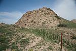
结构特点及构筑方式:山险位于山丹县城北部,南隔走廊平原与祁连山相望,是走廊平原与蒙古高原的过度地带,一般海拔在1600-3200米之间,相对高度800-1000米。山体呈带状分布,沿西北-东南向分布,属剥蚀中山,岩石裸露,山脊及阳坡物理风化强烈、岩石碎屑广布;此段山险起点第0050点,止点第0052点,全长1320米,是一段相对高度大于2000米的高山,海拔在2684米-2703米之间,山势陡峻,山顶尖峭,南坡坡度在60°-85°以上,岩石嶙峋突兀,山峰起伏连绵,较难攀登,北坡较为舒缓,坡度在40°-65°之间�
现状:
Type:山险 Precipitous mountain areas
Protection Level:
Content:
Memo:
Other Records:
Distribution:
visit location in Tianditu Map[recommend] Distribution:
visit location in Tencent QQ Map Distribution:
visit location in Google MapDistribution:
visit location in Baidu MapNational ID:620725382106040004
Action:[
 Save in Data Basket
 ]
Picture:
Click the thumbnail to view the Big Pic. Click the Big Pic to Hide the Big Pic![Caption:黄圪垯山险
loading images --Please wait...]() Photo Links
Photo Links:
 Search ::
  Favorite/My Favorite :: Recent Changes :: :: Login