Official Name:
青铜峡镇2段土墙QingTongXiaZhen2DuanTuQiangOur Name:
城西南墙 / ChengXiNanQiang
Other Name:
/
Period:明 / Ming Dynasty 1368~1644
Location: 宁夏回族自治区,吴忠市,青铜峡市,青铜峡镇西北约18.2千米――青铜峡镇西约18千米 / NingXiaHuiZuZiZhiQu,WuZhongShi,QingTongXiaShi,QingTongXiaZhenXiBeiYue182QianMiQingTongXiaZhenXiYue18QianMi
[
Looking Local List]
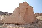
Details:长城类别:墙体
起点经纬高度:东经:105° 47′ 北纬:37° 56′ 海拔:1283
终点经纬高度:东经:105° 47′ 北纬:37° 55′ 海拔:1301
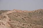
墙体走向:此段土墙自井沟北侧土墙的断口处(GPS0173点)开始,过井沟干涸的河道,继续向南,一直道今编号为53号的断口北侧边缘处(GPS0182点)截止,全长1737米,此段墙体随丘状台地地表分布,地势高低不平,落差较大;方向不甚直,大致呈北--南向。
墙体类别:土墙
结构特点及构筑方式:无。此段墙体是在原生沙土地表上直接找平、用黄沙土夹杂小石粒分段夯筑而成,土质粘细,质地细密,含水量少。属就地取材。
现状:土墙,
Type:土墙 Rammed earth wall
Protection Level:省保
Content:
Memo:
Other Records:
Distribution:
visit location in Tianditu Map[recommend] Distribution:
visit location in Tencent QQ Map Distribution:
visit location in Google MapDistribution:
visit location in Baidu MapNational ID:640381382101170018
Action:[
 Save in Data Basket
 ]
Picture:
Click the thumbnail to view the Big Pic. Click the Big Pic to Hide the Big Pic![Caption:青铜峡镇2段土墙
loading images --Please wait...]()
![Caption:青铜峡镇2段土墙
loading images --Please wait...]()
![Caption:青铜峡镇2段土墙
loading images --Please wait...]() Photo Links
Photo Links:
 Search ::
  Favorite/My Favorite :: Recent Changes :: :: Login